Randallsville Depot
by John Taibi
The Ontario & Western's depot at Randallsville was snuggled between the Northern Division mainline trackage, the Utica Division rails, and a connecting track that effectively formed a "Y" at this junction. Because of general freight, coal, and passenger trains destined to, or arriving from, Oswego and Utica (Rome), Randallsville was a strategic location on the O&W and, as you will see, might be considered the Cadosia of the Northern Division. However, it wasn't always that way.
When the Midland Railroad built the original depot here in 1869 the area had been known as Smith's Valley, and that was the name painted on a signboard and nailed to the board and batten building. Ironically, by this time the name of the hamlet had been changed the previous year to Randallsville, in honor of Postmaster General Randall who allowed a Post Office to begin operation here. In any case, it remained Smith's Valley on the railroad until May 24, 1880 when the O&W. changed the depots name to Randallsville.
During 1870, the Utica, Clinton & Binghamton Railroad completed their railroad from New Hartford to Smith's Valley, effectively making the Midland depot a UnionStation, and when the line was completed to the New York Central Railroad in Utica two years later the U.C.& B. was leased by the Midland who operated it as their own. In addition, the Midland had contracted with the Delaware & Hudson Canal Company to haul coal from the latters Pennsylvania mines and soon heavy coal trains began operating past the depot on the mainline and the Utica Branch to Oswego and Utica (Rome) respectively. (When the Midland went into receivership in 1873, the D.& H. C. Co. took over the operation of the Utica and Rome branches since they were the guarantors of the lease. Eventually, and for reasons of legality, the U.C.& B. and the R&C regained control of their own lines and again leased it back to the D&H Canal Co. Finally, on June 1, 1886, the branches were again subleased to the O&W. who operated them until March 29, 1957.) The first Smith's Valley Station Agent was H.T. Robinson and he worked the ticket window and telegraph desk (code "SY") until the Midland hit hard times. A succession of Agents came and went until March 1880 when Fred W. Hopkins arrived from the Munnsville depot to take over the Agentship at Randallsville. Fred found a home there and remained at "RW" (the new telegraph code) for just over 40 years!
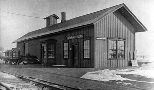
Tragedy struck the Randallsville depot on July 25, 1881. On that Monday a severe thunderstorm attacked the Madison County area, and lightning struck several O&W depots. At Eaton and Earlville the telegraph operators (Fitzgibbons and Larrabee, respectively) were injured when thelightning hit the telegraph lines while they were working the key. They both received minor burns. At Randallsville, the depot was the victim. Lightning from the storm struck the building, but despite the best efforts of Agent Hopkins the station was totally destroyed by the resulting fire. A boxcar was brought in to act as a temporary depot, and by the end of August masons arrived to put in a foundation for the new depot. This appears to be the first O&W built depot on the Northern Division.
The new O&W built Randallsville depot, shown here after an extension was put on in 1894, was narrower and longer than the original depot, and shows off its' bay window and cupola, both of which were not to be found on Midland built depots while in their original configuration. This is the depot that Fred Hopkins worked in for 39 of his 40 years at Randallsville. And, those forty years were the heyday of the railroad's operations there. By the Roarin' Twenties the once numerous and lengthy coal trains were becoming less frequent, and passenger service was on the verge of becoming extinct. On February 1, 1935 the railroad closed the agency at "RW" and a Caretaker was installed. But, a month later, the railroad saw the error of its ways and reopened the agency with Harry Lewis as Agent. In 1951, with William J. "Jimmie" Sheehan, Agent, the depot was formally closed and not to be reopened. The following year the depot was torn down leaving only a bare spot at the junction to remind the passing train crews of where the depot once stood. At one time, facilities at this important junction included along with the depot, a milk station, section shanty, water tank and standpipe, a maze of trackage, and an everpresent "water closet"- a two-seater!
Where all of this activity once took place, today there is nothing. The Cossitt Concrete Company has completely obliterated any trace of a railroad presence at Randallsville. Where heavy coal trains made there run for Eaton Hill, today there is everlasting silence.
Bartlett + Plymouth = Pecksport
During the year 1870 the Utica, Clinton & Binghamton Railroad was building south from Oriskany Falls towards Smith's Valley (Randallsville) in an effort to complete their line by connecting it with the New York & Oswego Midland Rail Road. Contractor Willis Phelps & Company had won the award to build the road (eventually they would also build the Rome & Clinton Railroad) and had sub-contracted the grading portion of the work to the firm of Foote & Canfield & Co., Phelps would do the actual track work. Contracts were also let for the building of the station houses on this portion of the line, with a depot to be built at Solsville, Bouckville, Pecksport, and Hamilton. Henry Powers, of Hamilton, was the successful bidder to build the depot in his village, while the building of the other three depots was awarded to Mr. H.J. Edgarton of Solsville. Mr. Edgarton's contract called for him to erect the depots at Solsville and Bouckville for $1900 each, and for the Pecksport depot, which was smaller, he was to receive $1700.
By the middle of May 1870 the Solsville depot was completed, the following month the board and batten Bouckville depot was ready for the business of the road, and in July both the Pecksport and Hamilton depots had been put up and were ready to be opened. Everything was now ready for the opening of the road which was delayed for several months due to track problems at the Hogs Back above Solsville and along Woodmans Pond near Hamilton. Finally, on Monday morning, September 26, 1870, the first passenger train on the U.C.& B. (to operate between Randallsville and New Hartford) headed north from Randallsville. Station Agents J.M. Banning (Hamilton), Alonzo Peck (Pecksport), Charles Dedrick (Bouckville) and Allen Curtis (Solsville) greeted the arrival of the train with enthusiasm and now eagerly set about their duties of conducting the business of the road.
Of the above four depots, the building at Hamilton receives the award for having the most charmed life since it is still in existence and is being used daily by a local cable company. The Solsville depot remained an agency right up to the last day of operations by the Ontario & Western Railway with Lavina "Lulubelle" Starkweather being the final Agent. At Bouckville the original U.C.& B. built depot was destroyed by fire and it was eventually replaced by a more modern depot built by the O.& W. This structure, though changed and added onto, survives as a well appointed antique shop. The depot at Pecksport burned to the ground in 1891 and was never replaced. While there are many historical and photographic records of the depots at Hamilton, Solsville, and Bouckville, it is the lack of evidence telling us what the Pecksport depot looked like that wraps this building in a shroud of mystery. Unraveling that mystery, which is the subject of this article, will lead us to several individuals, an historical society, and a still extant Oswego Midland built depot.
Lets start with what we do know. The depot was built on property acquired from the Peck family and, it was Alonzo who fashioned a port on the nearby Chenango Canal that became known as Peck's Port. Therefore, it was only natural that Alonzo Peck was named to be the first Station Agent for the railroad at Pecksport. There were no businesses of any consequence nearby to support the existence of the depot and so it was not too many years after the opening of the road (and after the death of Alonzo) that the Agent position was done away with and until the building succumbed to fire in 1891 the location was nothing more than a flagstop. The only indication we are given as to the size of the building is that it cost $200 dollars less than the depots at Solsville and Bouckville (which were 26X60 in size) therefore it is safe to assume that this was a smaller building. With everything else unknown we now begin our investigative work to solve the mystery of the Pecksport depot.
While doing research for my book entitled "Railroading in the Stockbridge Valley", I had the pleasure of making the acquaintance of Philip Munson. Phil has had a lifelong interest in the O.& W. since his father was a Station Agent at West Monroe and the Munson family lived for a period of time in that depot. In recent years Phil was the President of Clinton Historical Society. In his collection he has original papers reflecting the fact that the Rome & Clinton Railroad contracted with James Allin (of Madison) and James Hockridge (of Augusta) to build three depots. These three depots were to be located at Hampton (later to be known as Westmoreland), Clarks Mills, and Bartlett. In addition, their instructions were to use the U.C.& B. plans for that roads depots at Solsville, Bouckville, and Pecksport (respectively) thereby erecting identical buildings. For this work, Allin and Hockridge were to receive $5000.
While this information is still not helpful in determining the appearance of the Pecksport depot, it does tell us that the Bartlett depot was identical to our mystery depot. Enter A. Bruce Tracy, postcard collector extraordinaire and my co-author for the forthcoming book entitled "When the Railroads Went to the Beach". Bruce had acquired a postcard of an unknown depot and was eager to try to ascertain its location. While the building had some of the characteristics of an Oswego Midland built depot, determining the location was impossible due to the condition of the card and the size of the image of the building. However, after a chance visit to the Westmoreland Historical Society we were able to identify the location as Bartlett. In the Society's possession (and used in their book "A History of the Town of Westmoreland") was another photo of the depot at Bartlett and, upon comparing the image with Bruce's card it was easy to see that this was the same building.
By studying the two photos it was easy to see that the Bartlett depot was a 20X40 building, the smallest size depot put up by the Oswego Midland, the U.C.& B., and the R.& C. railroads. And, while it had all the earmarks of a Midland design, it did differ in one feature. That feature was the placing of an entrance door on the end of the depot rather than on the front as done by the Midland on their 20X40 depots located on the mainline. So, since the Bartlett depot was fashioned from the Pecksport plans we now knew what the latter depot looked like. But, since both depots do not exist we still won't have the opportunity to examine the structures. Or do we?
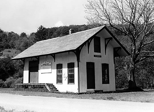
During July of 1998, the National Railway Historical Society was holding their annual convention at Syracuse, N.Y. As part of that convention, the Ontario & Western Railway Historical Society was to operate a bus trip to examine the remains of the railroad along a portion of the Auburn Branch and the mainline in central New York. One of the sites to visit was the depot at Plymouth, located just to the northwest of Norwich. When I visited Plymouth while preparing the route for the bus trip, I photographed the building (shown here) and realized that here was another 20X40 depot with an end door entrance. Why the Midland chose that feature over their normal placement of the front door we do not know, but we're glad they did. For we now have the opportunity to thoroughly examine the structure and can see exactly what the depots at Bartlett and Pecksport looked like.
The old Oswego Midland depot at Plymouth is cared for by the Plymouth Historical Society. Though it has been moved several hundred yards from its original location (and turned ninety degrees) it is an excellent example of the 1870's era of railroad architecture. The name on the signboard in this photo says "Plymouth", but change the name to "Bartlett", or "Pecksport" and you have the same building. What's in a name? In this case three identical, and beautiful, tiny little railroad depots!
"The O.& W. Loops, Sylvan Beach & Pecksport"
The American Heritage Dictionary defines the word loop as "a length of material that is folded over and joined at the ends or, any roughly closed turn such as a flight maneuver in which an aircraft flies a circular path or, in electricity a closed circuit". The Ontario & Western Railway had its own definition of a loop. To them a loop was a length of track that diverged from a main track only to rejoin the main track (or another main track) at a predescribed point further along the line. They put this definition into practice at two points on their Northern Division. While they accomplished improved operation of their trains over each Loop, the two lines were constructed for completely different reasons. The Sylvan Beach Loop was constructed first, in 1886, and was built to service the budding resort community along the eastern shore of Oneida Lake. Ten years later, the Pecksport Loop (officially the Pecksport Connecting Railway) was built to circumnavigate the ascending trackage over Eaton Hill.
The Sylvan Beach Loop...
One of the most important contributions the Oswego Midland Rail Road made to the State of New York was making accessible to the public large tracts of land that could be settled or enjoyed for its natural beauty. During the earliest years of the operation of the Oswego Midland the railroad acknowledged the fact that Oneida Lake was a wonderfully romanic body of water and, since their mainline ran in close proximity to the Lake, began a program of offering excursions to what was then called Fish Creek. By the mid-1870's, with the insistence of Northern Division Superintendent Charles W. Lanpher, the railroad built their own picnic grounds at North Bay where their track ran closest to the Lake.
During the summer season tourists trekked by train to "the beautiful sheet of water known as Oneida Lake". Most of the excursions landed the passengers at the North Bay picnic grounds but, by 1878, a man by the name of James Spencer began to cultivate his property into a magnificent picnic grove. This property, lying wholly along the eastern shore of Oneida Lake, immediately became the most popular destination for those desiring sun, sand, relaxation, refreshing breezes, and the unsalted water of the Lake. The problem was getting there.
The closest the Midland's mainline was to Spencer's Grove & Beach, was where the rails crossed the Wood River via bridges #366-368, which was about 1/2 mile distant from the Lake. The nearest depot, Fish Creek Station, was a little over one mile away. All of this meant that before the excursionists gained the Grove & Beach they had to do some hiking. Originally the Midland detrained all Lake bound passengers at Fish Creek Station. But, as the numbers of people wishing to get to the Lake greatly increased so did the pressure for the Midland to accommodate them more favorably. Trains were then stopped at the bridge which effectively reduced the walk to the beach by one half or, if they wished, they could ride a steamboat from the bridge landing down the Wood River to the picnic grove.
By the mid-1880's, and with the old Midland now known as the New York, Ontario & Western Railway, a further improvement was made towards handling the crowds desiring to get to the beach. At a point just north of bridges #366-368 a switch was installed in the mainline and a new section of track was put in that headed directly for the Lake. Upon reaching the Lake the track turned north to follow near the shoreline until the mainline was once again intersected. This new trackage was completed in May of 1886 and became foreverafter referred to as the Sylvan Beach Loop. At the point where the rails began to curve to the north, a southbound tail track was installed and it was on this tail track that the railroad put up their first depot. The railroad named the location Sylvan Beach and the name has remained to this day.
The Sylvan Beach Loop was used only during the summer season which was generally thought to be from the end of June to the beginning of September. During that time all trains traversed the Loop trackage. Passenger trains, freight trains, coal trains, ALL trains! Consequently, the mainline trackage between the two end points of the Loop was taken out of service. Once the summer season ended, a General Order was issued by Supt. Lanpher that closed the Loop and reopened the mainline.
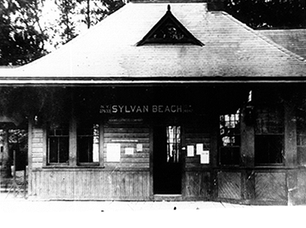
When the Gay Nineties arrived, the O.& W. realized that their depot at the "Beach" was totally inadequate in both size and appearance to handle, and be appreciated by, the crowds now descending on Sylvan Beach. So, during May of 1892 they began to erect a new depot which was more pleasing to the eye and able to satisfactorily handle the crowds of people arriving at the Lake daily. This new depot, shown here as it looked in 1909, was favorably received by the traveling public and thought of by many as the gateway to Oneida Lake.
A major adjustment to the use of the Sylvan Beach Loop occurred in 1907. At that time the New York State "1,000 ton" Barge Canal was under construction which precipitated major changes for the railroad in the Fish Creek-Sylvan Beach area. With the State footing the bill, a new bridge over the Wood River (soon to be the course of the Barge Canal) was built to replace bridges #366-368. In addition, an interlocking tower was constructed just north of the new bridge #367, its purpose being to more efficiently route O.& W. and Lehigh Valley trains (who crossed the O.& W. mainline at this point) across the bridge and, in addition, route O.& W. trains on/off the Sylvan Beach Loop. "SX" Tower completely streamlined the railroad's operations and directly led to a decision being made to use the Loop trackage all year rather than just during the summer season. It was at this time that trains began to call at Sylvan Beach 365 days a year.
But, all good things must come to an end, and the end for the Sylvan Beach Loop was brought about by motorized vehicles. The Oneida Castle-Sylvan Beach shuttle trains were discontinued during the 1926 season, Northern Division passenger service (other than the milk trains) was discontinued in this area in 1929, SX Tower was closed in 1930, and the Loop trackage was severed as a through route in 1933. By 1944 all of the Sylvan Beach Loop trackage had been removed, and the following year the depot was sold to O.& W. employee Ira Terry.
The existence of the Sylvan Beach Loop had, unfortunately, come full circle just as the term loop has been defined.
( A complete history of the Ontario & Western and Lehigh Valley railroad's service to Sylvan Beach will be chronicled in the forthcoming book entitled "When the Railroads Went to the Beach". A Fall 1998 arrival is expected.)
The Pecksport Loop...
The Pecksport Connecting Railway Company, a wholly owned subsidiary of the New York, Ontario & Western Railway, was organized on May 6, 1896 for the purpose of building a 3.8 mile link between the O.& W. mainline at Whites Corners with O.& W.'s Utica Branch at Pecksport. The Utica Branch from Pecksport to Randallsville (via Hamilton) to be utilized to reconnect the link with the mainline.
The idea for this line, which avoids the heavy grade over Eaton Summit (elev. 1320 feet), was originally conceived by the O.& W.'s predecessor the Oswego Midland Rail Road. Just two years after the opening of the Midland it was realized that to forsake the valleys by running the railroad at right angles to the mountains did not make for easy and cost efficient operation of the trains. Therefore, the idea of "lowering" some of the summits was investigated, and all eyes settled on Eaton Hill (from Randallsville to just north of Eaton station northward, and from Oneida Community to the same summit southward). The northbound climb was especially difficult due to that being the direction heavier trains traveled, especially coal trains received from the Delaware & Hudson Canal Company at Sidney Plains.
In April 1872, the Oswego Midland sent out a party of engineers to look for a way to get around the Hill. They staked out a line from the equally new Utica, Clinton & Binghamton Railroad at Pecksport to a point near Asa White's farm just south of the Midland's Pratts Hollow depot. That same month the Midland's Northern Division Superintendent McKinley let out a contract for the grading of the new line and everything looked as though this improved route would be built. Until President Dewitt C. Littlejohn came on the scene. He looked over the survey and the scene and "determined to postpone laying the new track until another year". For the Midland, another year never came. Financial difficulties developed, Littlejohn resigned, and so the trains continued making their run for Eaton summit.
The Ontario & Western Railway continued the tradition of operating over Eaton Hill but, with the opening of their new line to Scranton in 1890, they again looked for ways to move their heavy coal trains north from Randallsville. As early as December of 1892 the question of building a new line around Eaton Hill was brought up, and the following year the railroad spent $264.84 to have another survey done. That accomplished, nothing more was done until the spring of 1896. In April of that year, the railroad's engineer C.E. Knickerbocker was sent to Pecksport with the orders to do a final survey from which a connecting link could be built.
The Knickerbocker survey team proposed four alternatives for the route. They were named "Route A", "Route B", the "Morrisville Line", and the "Direct Line". Routes A & B were located between Pecksport and Leland's Pond (a New York State reservoir for the Chenango Canal, approximately one mile north of Pecksport), The Morrisville and Direct lines were between Leland's Pond and Whites Corners. Despite the fact that Route A cut across a portion of the pond and would have to be filled in, it was selected along with the (you already guessed it!) Direct Line. These combined survey routes, which entirely made up the Pecksport Connecting Railway, located the route as being 3.8 miles long not including eventual yard trackage and passing sidings. In addition the link built on these routes would effectively "lower" the summit by 170 feet.
The grading for the P.C.Ry. began in May of 1896, and by August all such work and track laying had been completed. The line only had to be ballasted in order for it to open with the issuance of the new Fall (Sept. 13, 1896) timetable. Also to be erected were small train order offices at both Pecksport (the U.C.& B. built depot had succumbed to fire several years earlier) and Whites Corners at a location that the Midland had originally considered for the site of its Pratts Hollow depot. When the opening day arrived, and with little fanfare, the new connecting link went into service. With this new trackage in place, the following elevations were summits for the indicated lines:
Mainline- Eaton 1320 feet,
Utica Branch- Pecksport 1118 feet, and
Pecksport Loop- Whites Corners 1150 feet.
From this it can be discerned that on the Loop there is only an 32 foot increase in elevation northbound from Pecksport to Whites Corners. On the mainline between Whites Corners and Randallsville only local passenger and freight trains and the milk trains continued to ply the rails, all other trains now traversed the Loop trackage.
While the communities of Morrisville and Eaton (both actually lying a distance west of the O.& W. mainline) were aggravated over the loss of rail service to their depots, the village of Hamilton was elated. Finally it had achieved the railroad status it deserved, since trains bound to and from the Loop now passed their depot which was located within the village limits. Along with this improved status the village fathers agitated for a new depot to be built which the O.& W. agreed was in order for such an important community on its line. Hamilton has been a two depot town eversince. The original U.C.& B. depot was moved just to the north, and the new depot was put up on the site of the original depot.
With the opening of the Pecksport Loop, Hamiltonians liked to think of their village as now lying on the "mainline" of the O.& W. However, officially, this was not the case. While it is true that the preponderance of heavy freight traffic, the long distance passenger trains, and all trains on the old U.C.& B. did indeed pass through Hamilton, the railroad traditionally referred to this location as being on the Utica Branch. It was only near the end of World War Two that the O.& W. officially designated the mainline as running through Hamilton and Pecksport to get to Whites Corners. At that time the old mainline between Randallsville and Whites Corners via Eaton and Morrisville was designated as the Eaton Line.
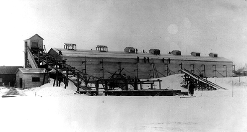
The only structure wholly situated on the Pecksport Loop was the Fargo's Icehouse which was slightly more than a mile distant from Pecksport. More appropriately, icehouses since there were several different ones erected there. As mentioned above, the Loop ran in close proximity to Leland Pond, actually at its eastern shore. The railroad negoiated with the State of New York for permission to harvest ice from the Pond, the water not being used any longer for the Chenango Canal. By the end of 1896 the railroad had begun the building of the first company icehouse. In 1903 the building was added onto, but during 1914-15 an entirely new ice house (shown here) was built parallel to the O.& W.'s tracks. This building, which was 28X210 in size, completely overwhelmed the Pond's shoreline. Ice from Leland Pond was stored in the building and used to replenish the supply of ice at other company owned icehouses. The harvesting season was traditionally sometime near the end of January or begining of February. Sometime during the first half of the 1930's, with the building having outlived its usefulness, it was torn down for its salvageable materials.
The Pecksport Loop was used by the Ontario & Western right up until its last day of operations on March 29, 1957. Its legacy is that it improved upon the original Oswego Midland route by lowering the crossing between Randallsville and Whites Corners thereby allowing locomotives to more than double their tonnage rating on this portion of the railroad and only adding an additional .55 of a mile between the two points. During August of 1958 the track was removed from both the old mainline and the Pecksport Loop by Seaway Industries. Where once commerce plied the rails, now Mother Nature was able to reclaim her property, secure in knowing it would never be taken from her fold again.
(A complete history of the Pecksport Loop will be included in a future O.& W. Historical Society Observer issue. Entitled "A Hill, A Branch, and the Pecksport Loop" this Observer will deal with Eaton Hill, the Utica Branch, and the Loop itself.)
Fargo Ice House photo courtesy of the Robert F. Harding/Jack W. Farrell Collection
Bridge #282, the Lyon Brook Bridge
During the year 1869 the actual construction of the New York & Oswego Midland Rail Road (two words, railroads were new back then!) began in earnest. Men worked at excavating the needed cuts while others filled in low areas where the grading crews would soon arrive. Wooden trestles were erected where needed, and finally track laying gangs laid iron rails end to end, on rough hewed ties, gauged and spiked the rails in place, and continued their dance until an almost continuous iron road was put down. There were, however, several areas that required more engineering ingenuity, consequently more time was needed to complete these portions of the right-of-way. Tunneling through the Shawangunk ridge, conquering the elevation of Northfield Mountain, traversing the valley at Sidney Center by several curved trestles, and bridging the Lyon Brook ravine were the difficult engineering feats that had to be completed to begin through train operations of the Midland.
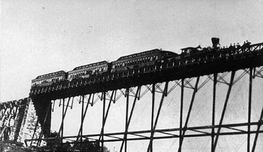
By the middle of 1869 workmen began arriving to commence work on what would become the engineering landmark of the Oswego Midland's Northern Division, the bridge over the Lyon Brook. This bridge, located between Norwich and Oxford, was planned to be 830 feet long, and its center 100 foot span was to be located 155 feet above the its namesake brook. During July and August the abutments needed to hold the iron superstructure were put up, utilizing in part flagstones from the nearby John Shattuck farm. In short order, caps were put on top of the abutments and everything was in order to begin erecting the ironwork. Contractors Smith, Latrobe, & Co. began receiving the bridge iron members from the Phoenix Iron Works in Philadelphia, and with Mr. Latrobe personally supervising the placing of the iron members, the lofty crossing of the ravine began. It was during this period of construction that a crowd of onlookers seemed always to be present. These curiosity seekers marvelled at how the workmen were able to work so high in the air, and while they wished for the safety of the men, they wanted to be there to witness a tradegy should that occur.
On October 15th, with the everpresent onlookers in attendance, the 100 foot Frink truss section was put in place directly over the ravine. With this section in place the onlookers, and certainly Mr. Latrobe himself, were satisfied that the bridge could be completed. Through November and on into December the work continued to complete the bridge. By this time the Midland was operating a regular schedule of trains from Oswego to Norwich and was only awaiting the completion of the Lyon Brook Bridge to extend the operation of trains to a connection with the Albany & Susquehanna Rail Road at Sidney Plains. Finally, just two days before the Christmas of 1869, with the trackwork installed atop the iron bridge, the first train was sent out onto to the completed bridge to test the span. Though there were nearly 2000 people in attendance to witness the trial of the bridge, not a sound was uttered until the train (consisting of a locomotive, 6 flat cars, and 2 passenger coaches) reached terra firma after crossing the span. At that time the crowd cheered, the locomotive whistle was blown, all done to announce that man had overcome a natural barrier.
Even before regular train operations began to Sidney Plains (on June 15, 1870) passenger excursion trains were regularly run to the bridge for people from far and near to view the completed wonder for themselves. It appears that the first excursion to the completed bridge was run on New Years Day of 1870. As reported in the Norwich Chenango Union newspaper, "upon arriving at the north end of the bridge, the train stopped, and most of those onboard walked out onto the bridge which was fitted up with substantial railings and a plank walk on both sides. Looking down from the dizzy height, at the seemingly frail supports, one can hardly believe it possible that the bridge can bear the heavy burdens which must cross it. After viewing the structure, the company repaired to the train which then slowly ran onto the bridge as far as the center where it halted a few minutes before starting back to Norwich". On a subsequent trip run on May 5, 1870, some passengers were not content to view the bridge from just the top. "We clamered down the banks of the Lyon Brook and into the chasm over which the celebrated structure stood, its iron network resembling more a horizontal cobweb than the firm and substantial work it is. Its height cannot be appreciated by riding over it. One must go down and then look up to be conscious of its altitude. We advise everyone not to miss a sight of it from the level of the water". Whether viewed from above or below, the Lyon Brook Bridge was an impressive structure that by itself alone brought much needed revenue to the fledgling Midland Rail Road. One such early excursion is shown here just getting fully onto the bridge from the north end. The locomotive is #4, the "Delaware" with three early coaches coupled to its tender.
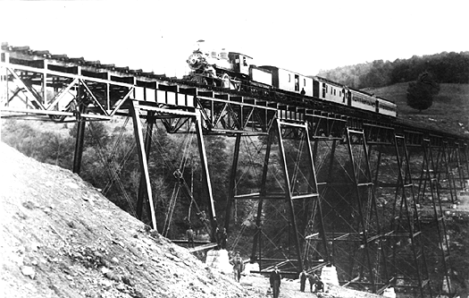
With the opening of the railroad to Sidney Plains the Lyon Brook Bridge was put to the test on numerous occassions daily and served the Midland well despite the railroad's financial difficulties. When the railroad was sold to a group of investors and became the New York, Ontario & Western Railway the bridge would continue to serve its new owner faithfully. But, winds of change were in the air. Ten years after the O&W took over the operation of the old Midland, President Fowler officially opened the railroads new Scranton Branch, on June 30, 1890. This new line, which tapped the lucative coal fields of the Lackawanna Valley, brought about the O&W's entrance as a coal hauler. While it is true that the O&W(and the Midland before) had contracts to haul coal for the Delaware & Hudson Canal Company, the opening of this new branch meant an increase in the tonnage to be moved to tidewater and to the lake. To more efficiently handle this increased tonnage, the O&W set about improving its up and down profile, especially north of the junction with the mainline at Cadosia, while at the same time increasing the capacity of its many bridges. Towards this end, the railroad completed its Zig Zag Tunnel (June 25, 1891) which lowered the summit of Northfield Mountain, and before completing the Pecksport Loop (Sept. 13, 1896) which reduced the grade from Randallsville to Oneida it also completely rebuilt the Lyon Brook Bridge.
Contracts for the rebuilding of the bridge were made during February of 1894. The masonry for the new piers was begun in May, and during June the erection of the new steelwork commenced. The new structure contained eight plate girder tower spans of 30 feet each, three spans of 80 feet, four spans of 60 feet, and two spans of 50 feet, a total length of 820 feet. On August 15, 1894 the "new" bridge #282 was completed at a cost of 35,342.51. And, surprisingly, all the work was done without an interruption of train service! Now, heavily loaded coal trains, powered by more modern locomotives, were able to speed towards their destination of either Utica, Rome, or Oswego untethered to the light weight restrictions of the original bridge. Pictured here on the newly rebuilt bridge is a northbound accommodation train obviously stopped on the bridge for its portrait. Notice the more substantial steelwork as compared to the original ironwork.
As expected, this structure was a Very important location on the railroad. So important that during the years of World War II the bridge was guarded 24 hours a day to protect it from any form of espionage. An observation post was established on the south side of the bridge, and a small gable roofed shanty put in place to house the watchmen. Whether any "Nazi" or "Jap" sympathizers ever had any designs on sabotaging the Lyon Brook Bridge is questionable, nevertheless you could say that the guards were certainly successful in protecting the bridge and performing their duties.
The rebuilt Lyon Brook bridge served the O&W well until the railroad was abandoned on March 29, 1957. The last weight it had to shoulder was that of the scrap train that removed the rails from the bridge the following year. For another eight years the structure stood over the Lyon Brook but, during March of 1966, Price Demolition Co. of Appalachin, N.Y. began the dismantling of the structure. The following month, what had been a landmark of a once prosperous railroad was completely removed from its longtime setting, leaving nothing but the supporting piers and memories of a once cheering crowd when the first train inched out onto the structure in 1869. Whether any curosity seekers were in attendance during March and April of 1966 is not known. Maybe it would be better if there weren't any. The demise of wonders of the railroad engineering world is not pleasant, their souls would rather we remember their majesty, their impressiveness, and their job well done! Remember their being, not their passing. Towards that end, an historical marker has been placed along East River Road (just south of Polkville, N.Y.) where the Lyon Brook chasm can be seen in the distance.....Once upon a time there was a great bridge there!